![PortStrategy[GreenPort]](https://www.portstrategy.com/wp-content/uploads/2026/09/PortStrategyGreenPort.svg)




A view of the truth
Geographic Information Systems can bring visibility to ports as John Bensalhia explains
Throughout history, variations of Geographic Information Systems (GIS) have been devised. A prototype was assembled by physician John Snow in 1854 to deal with the source of a cholera outbreak in London. In 1960, the first bonafide example was developed by geographer Dr Roger Tomlinson in order to store, analyse and use information gathered for the Canada Land Inventory.
Today, GIS has progressed immeasurably, thanks to technological advances. With sophisticated technology and data facilities, GIS is invaluable for ports. As Graham Wallace, senior business strategist for Esri UK says, GIS provides “one single view of the truth”.
“Data collected from diverse in-house and external systems in a non-visual format can be presented in a readily usable, visible format ie: on a map. Map-based information can then be interrogated to understand why there are variances in a specific location, adding an extra dimension to data management and analysis.”
Daniel Elroi, president of NorthSouth GIS LLC, identifies vital performance capabilities. “GIS is a critical tool for helping ports to increase revenues by identifying under-performing real estate and helping to attract new tenants; reduce costs from time lost in searching maintenance costs of assets and correlating them to the rent rolls and general ledger, or time and accuracy lost from the re-entry of field inspection notes back in the office; and to increase return on investment from engineering projects by integrating project data back into the overall base maps of ports.”
GPS vs GIS
While GIS can offer these benefits, if ports use GPS (Global Positioning System) – which provides excellent tracking capability – then why is GIS necessary?
Mr Elroi explains the distinctions between the two: “What most people think of as ‘GPS’ when referring to an in-car navigation system is, in fact, a GIS. GPS provides the location, the dot on a digital map. But the digital map itself, the ability to determine route alternatives; search for restaurants along a route; switch between a street map background or ‘satellite’ imagery; or zoom in and out to see different levels of detail, are functions of GIS.”
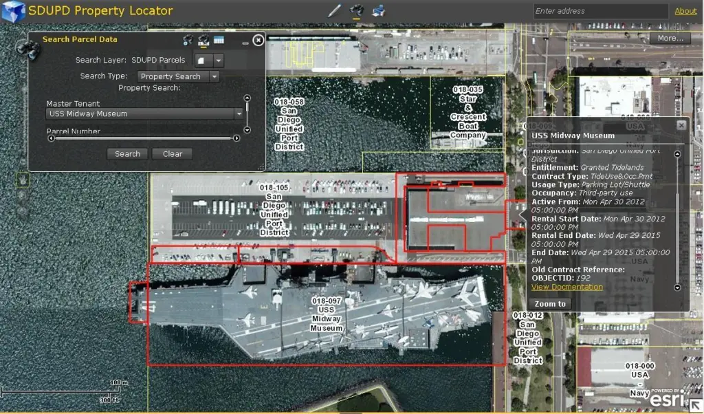
“GPS tracking is a layer that resides on top of GIS features,” adds Malcolm Meikle, GIS co-ordinator at San Diego Unified Port District. “The GPS layer is a geocoded event that shows the global position of an object. The GIS underneath gives texture and location to the given GPS event. The GIS can also store GPS event information such as vehicle tracking for future review or it can assess first responder locations to emergency situation.”
“Global Positioning Systems provide the means to precisely locate critical port resources in their true positions both absolutely and relative to other port infrastructure,” says Frank Orr, transportation industry manager of Critigen. “However, GPS data collection and tracking is only as good as the enterprise spatial information with which it is combined. When integrated with a well-designed enterprise GIS, GPS tracking can provide efficient management and operation of automated container placement as well as facilitating the automation of the pick-up, transfer, and placement of containers by tracking them from port entry to exit.”
Mr Wallace says that a notable strength is that information can be shared collaboratively. “For example, security breaches are the concern of the security team, while spillages may require data to be distributed to external functions such as the Environment Agency and the relevant Emergency Services. In this way while GPS provides source data, GIS can be used to analyse business performance to create actionable insight, designed to increase revenues, identify opportunities to reduce costs, enhance safety procedures and reduce risk.”
Payback points
A key advantage of GIS is that it can bring good return on investment. Mr Orr says that while GIS investments can be relatively minor compared with a port’s annual operating budget, ROI can be significant. “Ports can realise immediate financial benefit from modest investments in GIS software, data, and infrastructure. Hosted GIS, or GIS in the Cloud, can facilitate quick start-up and also ease dissemination of benefits across the port enterprise. The cost of hosted GIS can be small initially, enabling ports to provide data and services immediately without investing in physical infrastructure and server-based software.”
The secret to getting good ROI is to devise a detailed GIS implementation plan based on a thorough needs assessment. Mr Orr says that by using such a plan, “ports can devise a ‘road map’ for implementation that focuses on maximising initial ROI in order to fund more ambitious implementation components in future years.”
As Mr Elroi points out though, the real ROI is in the things that are harder to gauge. “The gas line that wasn’t dug up late at night on a weekend and shut the port down, because the gas line was mapped in GIS and accessible in the field; the environmental violation that wasn’t issued and shut down a terminal because the field crews get through more inspections in less time and can submit the results electronically now; or the lives that were not lost because a timely Tweet pointed to a current evacuation map and helped people flee a disaster at a port.”
With respect to redundancy levels, Malcolm Meikle says that each GIS should have a Development, Test and Production platform. “The top two levels of the system, that being Test and Production, should mirror each other. All systems and data should have a defined backup schedule.”
“Redundancy, business continuity, and data backup and retrieval are all as important with a port’s spatial information management system as with any other enterprise system,” says Mr Orr. “However, even major ports are not necessarily in the business of building and maintaining enterprise data centres. GIS databases, services, and applications all require some level of managed backup and recovery in order to avoid any system downtime in the event of an emergency. GIS databases require specialised replication protocols to ensure that services can be restored quickly and completely. A private or public Cloud model can be employed to provide the required backup and recovery.”
Cloud atlas
Mr Orr adds that the future of GIS will be more in the Cloud as ports recognise the potential of Cloud infrastructure and services. “GIS Software as a Service will grow in complexity and reliability and more GIS functions will be performed using an annual user subscription fee or a ‘pay by the drink’ model.”
“As each year passes, Esri GIS technology is becoming more integrated with core business processes,” says Mr Wallace. “The launch of Esri Location Analytics plugging GIS into existing BI systems, to help visualise silos of data that would otherwise have remain hidden, is a prime example.”
Other recent Esri GIS developments include ERP integration, inter-operability with all the standard mobile operating systems (including Android, IoS, and Blackberry) and the growth of cloud-based SaaS services. Mr Wallace comments: “In the immediate future, we can expect to see significant enhancements to the collaborative online GIS tool kits, much greater integration into GPS enabled data feeds and new tools to analyse patterns generated by huge quantities of mobile data.”
“There are important trends in GIS that will benefit ports in the near future,” concludes Mr Elroi. “The re-focus on geospatial technologies as business process automation tools, rather than merely as digital mapping tools, and the convergence of these technologies with standard IT technologies, is bringing GIS out of the basement and into the executive suite at ports.
“Emerging data models for ports, such as those developed by NorthSouth GIS and by Esri, make it possible for ports to be able to manage all that is on land, on the water and below the waves without having to reinvent the wheel each time.”
Related Articles
 CONTAINER & CARGO HANDLING
 CONTAINER & CARGO HANDLING
 BULK HANDLING