Port Botany Expansion
The Port Botany Expansion is a $1 billion, 60 hectare reclamation project in Botany Bay adjacent to the existing Patrick container terminal at Port Botany. The expansion will provide significant additional container capacity at the port to meet projected long-term trade growth.
History of Penrhyn Estuary
Penrhyn Estuary formed following reclamation works associated with construction of the existing Port Botany and Foreshore Road area in the 1970s. Since that time, the Estuary has developed into an ecosystem which includes saltmarsh and seagrass species and intertidal flats that have become feeding and roosting sites for locally important shorebirds. The estuary has become home to a wide variety of flora and fauna, many of which are protected by state and commonwealth legislation. A range of issues have affected the environmental health of the area including stormwater runoff from neighbouring urban and industrial sites, poor water quality, contaminated estuarine sediments, spread of noxious weeds, degraded vegetation, proliferation of mangroves, beach and dune erosion and rubbish dumping. The estuary and the flora and fauna within it have been subject to human disturbances as well as dogs and feral animals within the area, which pose threats to roosting and feeding shorebirds and can damage vegetation along the foreshore of the estuary. Sydney Ports has recognised the importance of Penrhyn Estuary as essentially the only habitat remaining for shorebirds formerly abundant in the northern part of the Bay. A Penrhyn Estuary Habitat Enhancement Plan (PEHEP) has been prepared and is currently being implemented, to reverse the decline of Penrhyn Estuary and to enhance key ecological features of the estuary.
Penrhyn Estuary Habitat Enhancement Plan (PEHEP)
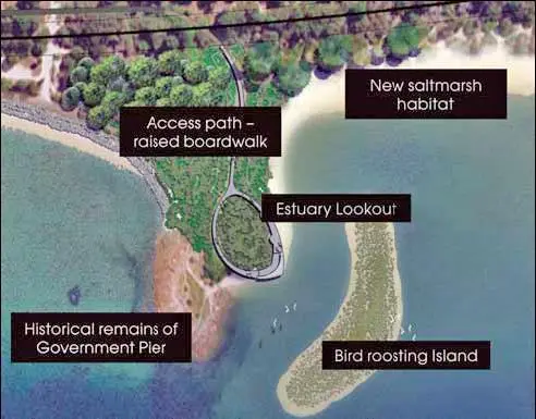
Sydney Ports Corporation developed a detailed estuary design plan titled the Penrhyn Estuary Habitat Enhancement Plan (PEHEP), to rehabilitate and expand Penrhyn Estuary to secure it as long term habitat for migratory shorebirds and their associated habitats. The aim of these works is to continue to attract key migratory shorebird species that currently use the Estuary, and potentially attract a greater number of shorebirds. The PEHEP outlines the objectives, design, management and monitoring for Penrhyn Estuary. The design includes: the creation of intertidal flats, saltmarsh and seagrass habitat; control of public access by means of a pedestrian boardwalk and viewing platform extending a short distance into the estuary to minimise disturbance of the shorebirds and damage to sensitive saltmarsh and seagrass habitats; relocation of the current public boat ramp away from Penrhyn Estuary; fencing of the estuary to prevent access by feral animals and the public. When complete, the Estuary will extend over an area of about 26 hectares.
Shorebirds
Due to the decline or removal of other available habitats, Penrhyn Estuary has become the only viable feeding and roosting site for locally significant migratory shorebirds on the northern side of Botany Bay. The estuary is located on the East Asian- Australasian flyway used by thousands of migratory birds, such as the Bar-tailed Godwits which every year commute 12,000 kilometres each way between Botany Bay and the Arctic Circle. However, over recent years the suitability of the estuary as a shorebird habitat has been under increasing pressure as a result of mangrove encroachment, contaminated surface and ground waters and increased disturbance from public recreational usage of the area. The enhancement aims to secure the Estuary as long term shorebird habitat through:
• Creation of additional intertidal flats to increase the area of feeding habitat four fold;
• construction of three islands to create secure roosting sites; protection of existing and planting of additional saltmarsh vegetation; removal of mangroves which have reduced the areas of feeding and roostinghabitat for shorebirds; prevention of access by recreational vessels, people, pets and feral animals. In addition, the provision of a boardwalk and public viewing platform with a bird hide and interpretive signage to enable viewing of the estuary without disturbing shorebirds using the site and to prevent public access to tidal flats
Intertidal Flats
The creation of additional intertidal flats will increase feeding area for shorebirds. The estuary is currently made up of approximately 3.4ha of intertidal flats suitable for the shorebirds and as part of the project Sydney Ports is extending this to 13.8ha. Much of this habitat will be created by the removal of dunes west of Flood vale Drain and the filling of deeper parts of the estuary with sand from the dune and/or clean dredged material. To assist in colonisation of benthic organisms (bottom dwelling invertebrates such as worms) the surface of new intertidal flats will be covered with material from shallow dredged areas. The early establishment of benthos within this habitat is important to ensure an ongoing food supply for shorebirds.
Bird Roosting Islands
As a result of the construction of the new port terminal, the current roosting areas in the outer estuary will be removed. To ensure continued availability of suitable habitat for the shorebirds a temporary roosting island has been constructed from clean sand within the estuary. This temporary roosting island will be replaced by the final design of three roosting islands. These islands will be constructed using clean sand and elevated so that they are only occasionally covered by king tides. The total area of the islands will be 1650m2 and one of the islands will have small rocks and associated epifauna relocated from existing feeding sites adjacent to the estuary into the new habitat.
Mangrove Removal and Transplant
To increase the suitability of the area as a shorebird habitat, the mangroves within the estuary have been removed. The mangroves are seen as detrimental to shorebird habitat as they colonise shorebird feeding and roosting habitat and compete with saltmarsh for space. Mangrove seedlings and plants less than 1 metre in height were removed manually and donated to ABI Group and a partnership of Sutherland Shire Council, NSW Maritime and National Parks and Wildlife, who transplanted them to Georges River at Alfords Point and the Hacking River at Port Hacking respectively.
Saltmarsh
Penrhyn Estuary is home to a variety of saltmarsh species which are listed as endangered ecological communities under the NSW Threatened Species Conservation Act 1995. Saltmarsh is important as it provides habitat for the shorebirds that use the estuary. Saltmarsh also plays a key role in stabilising the banks of estuaries, filtering surface runoff, reducing nutrients and providing habitat for fauna. Penrhyn Estuary currently has about 1.4ha of saltmarsh comprising the species of Sporobolus quinquefl ora, Suaeda australis, Isolepis nodosa, Juncus Kraussii and Juncus acutus.The enhancement of the estuary will see this area increase to 3.8ha. 0.4ha of the existing saltmarsh is currently being transplanted to prevent it being lost as part of landform changes to the west of Floodvale drain for the creation of intertidal flats. The Sarcocornia and Sporobolus species within this area will be transplanted to existing saltmarsh habitat within the estuary.
Saltmarsh Seedlings
As part of the habitat enhancement for the Estuary, 2.4 ha of additional saltmarsh habitat will be created and planted with a mix of saltmarsh species. This will be done by planting saltmarsh seedlings grown from seed or stem pieces primarily collected from within Penrhyn Estuary. The seed collection has been completed and propagation has begun. In excess of 200,000 seeds will be propagated at 2 nurseries around Sydney and then planted within the Penrhyn Estuary site. The saltmarsh species mix to be planted in the Estuary will have greater diversity than the existing community.
Monitoring
The PEHEP also outlines the extensive monitoring which underpins the habitat rehabilitation and expansion and will be used to determine success of the Estuary works. Pre-construction monitoring has been completed. Monitoring will continue during and post construction. Sydney Ports Corporation is committed to managing and maintaining Penrhyn Estuary under a long term arrangement with NSW Maritime. Environmental attributes to be monitored include saltmarsh, seagrass, benthos, shorebirds, water quality and sediment.
Foreshore Beach Public Recreational Area
The Port Botany Expansion also entails extensive works along Foreshore Beach, to improve the public recreational amenity of the area. The redevelopment of Foreshore Beach will see $30 million spent on works – for further details of the Foreshore Beach plan and more details on the whole project see: www.sydneyports.com.au/port_botany_expansion_project