![PortStrategy[GreenPort]](https://www.portstrategy.com/wp-content/uploads/2026/09/PortStrategyGreenPort.svg)


Time to bring consistency between pilot and bridge?
Dave MacIntyre asks whether it is time for ports worldwide to look at the charts available for berthing, to ensure pilots and bridge teams are working with the same information.
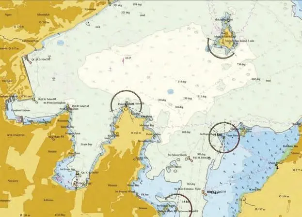
This topic became a discussion point at the recent conference of the New Zealand Maritime Pilots’ Association after a presentation by Land Information NZ (LINZ). LINZ incorporates the New Zealand Hydrographic Authority
which produces official nautical charts for safe navigation in New Zealand waters and certain areas of Antarctica and the South-West Pacific.
The issue which came up for debate is whether there needs to be consistency between the charts for port berths which are available locally and those which are available digitally.
There is a minimum scale for berthing charts to be compliant but apparently, some ports may not have them to that level of detail in electronic form, which means pilots revert to using charts which are available locally. The question then is that the information being used by the ships’ bridge crews in their digital ECDIS charts (Electronic Chart Display and Information System) may not show the same detail as the information loaded on the pilots’ PPUs (Personal Pilot Units). If so, is this an impediment to achieving the “shared mental model” that should exist when the pilot-master exchange of information occurs on the bridge?
Numerous maritime accident investigations globally have pointed the finger at accidents and incidents which have occurred with ships under pilotage, where the master and bridge team have not been fully conversant with the passage and berthing plan.
Had they been so, the bridge team could have intervened and questioned the pilot when they saw a manoeuvre taking place (or an expected manoeuvre fail to take place) which contravened their understanding of how the passage plan would be executed.
Port Strategy contacted Adam Greenland, the National Hydrographer for Land Information New Zealand, who confirmed there is a minimum international scale for charts to be used for the berthing of ships in ports.
The scales of charts, both paper and Electronic Navigational Charts (ENC), are specified by international standards developed and maintained by the International Hydrographic Organisation (IHO) – IHO S-4 Regulations for International (INT) Charts and Chart Specifications of the IHO, and IHO S-57 IHO Transfer Standard for Digital Hydrographic Data, Appendix B.1, Annex A – Use of the Object Catalogue for ENC–UOC.
The IHO is an intergovernmental consultative and technical organisation that supports safety of navigation and the protection of the marine environment. It is recognised as the competent international authority regarding hydrography and nautical charting and cooperates closely with international organisations, including the International Maritime Organization (IMO).
Mr Greenland says ports and harbours worldwide conduct routine hydrographic surveys in their area of jurisdiction, for approaches, channels and berths.
“This survey data is compiled into local charts for the use of the port users such as pilots, in addition to official charts,” he says, adding, “This is compliant with SOLAS and NZ carriage requirements.”
He further confirms that “there is no compliance issue in New Zealand. Pilots’ PPUs may use local charts with official charts, ships’ ECDIS may only use official charts.” However, given that local charts may have more detail than those available to ships internationally, the issue remains as to whether the information loaded on both the ship’s ECDIS and the pilot’s PPU can be brought up to identical standards?
Mr Greenland says the IHO has recognised the benefit of both PPUs and ships’ ECDIS using official high-density bathymetry charts for navigation in pilotage waters. A new IHO product specification has been developed (S102 Bathymetric Surface Product Specification) to create and maintain these new charts which is undergoing ship-borne trials around the world. It seems a positive step forward to achieving the desired “shared mental model” on the bridge.
Related Articles
 WORLD
WORLD
 PORT & TERMINAL NEWS
 PORT & TERMINAL NEWS