![PortStrategy[GreenPort]](https://www.portstrategy.com/wp-content/uploads/2026/09/PortStrategyGreenPort.svg)


Finding lost boxes
Terminal operators are investing in state-of-the-art position detection systems to streamline box management, writes Patrik Wheater
Position Detection Systems, originally based on GPS (global positioning satellite) technology, have come on leaps and bounds since their first introduction in the late 1980s.
Some of today’s systems have evolved to form a modular set of core components from which various additional modules can be added to increase system functionality. This has included not only GPS and positioning and detection systems (PDS) information, but VMT (vehicle maintenance tracking) driver screens, RFID (radio frequency identification) automatic move selection, security authorisation, maintenance logging and reporting, statistics logging, equipment automation and several other features.
Over time this has allowed stable standard modules to evolve to provide a high degree of port-to-port customisation without the risk of major system changes.
International Terminal Solutions (ITS), one of the pioneers in container positioning and detection systems (PDS), having first supplied solutions as long ago as 1988, has used its experience to develop the next generation system that claims to avoid obsolescence issues allowing for future-proofed, reliable system design.
A couple of years ago, ITS launched its G-POS system. The first generation was originally installed on rubber-tyred gantry cranes and provided the modular hardware base for ITS’ modular functionality. However, the UK-based company has been working on a range of G-POS hardware platforms and is now able to offer the G-POS compact, and G-POS mini to allow ITS systems to be installed on any type of container handling equipment.
According to ITS’ Richard Lambert, the company has been inundated with enquiries, many of which have now firmed into contracts. And this year ITS will install its full range of G-POS systems in RTGs, RMGs, straddle carriers, reachstackers, empty handlers, and IMV Trucks for several customers.
It is interesting to note that all the G-POS units use a common set of hardware components allowing full inter-changeability between the G-POS units and all the G-POS units to run all the functional modules. As such it is very easy and cost effective to upgrade any unit to add more functionality, says Mr Lambert.
For example, one particular terminal has been operating ITS’s PDS systems for over 17 years. Over that time the systems have been upgraded several times, allowing the client to stay one-step-ahead without the need for system replacement.
“To ensure the systems don’t get caught in the ‘proprietary hardware’ trap, the ITS modular hardware components have been carefully selected to allow swap compatibility with a range of commercially available platforms. This means that if a computer or communication board becomes obsolete it can be substituted for another one without modification or system replacement,” says Mr Lambert.
For the terminal operator, the implementation of a container positioning system is key to keeping track of the location of containers. As one terminal operator that has developed its own in-house solution told Port Strategy: “The accuracy of container location, what we term as yard integrity, is extremely valuable because it allows each box to be located precisely, eliminating the time wasted finding missing boxes. There are various types of technologies used to locate container positions but, whichever technology is used, the critical factor is that the yard crane operator must handle the right box and update the system accurately.
“In other words, a terminal can have the perfect technical solution but still cannot achieve perfect yard integrity because of human errors.”
While the human factor will never be wholly obsolescent, GPS and DGPS-based positioning systems can reduce the risk of a straddle carrier operator picking up a wrong container, placing it in the wrong location and losing it indefinitely.
When this occurs, the only way of retrieving the box is to physically hunt around for the thing, which can be a time-consuming and costly exercise.
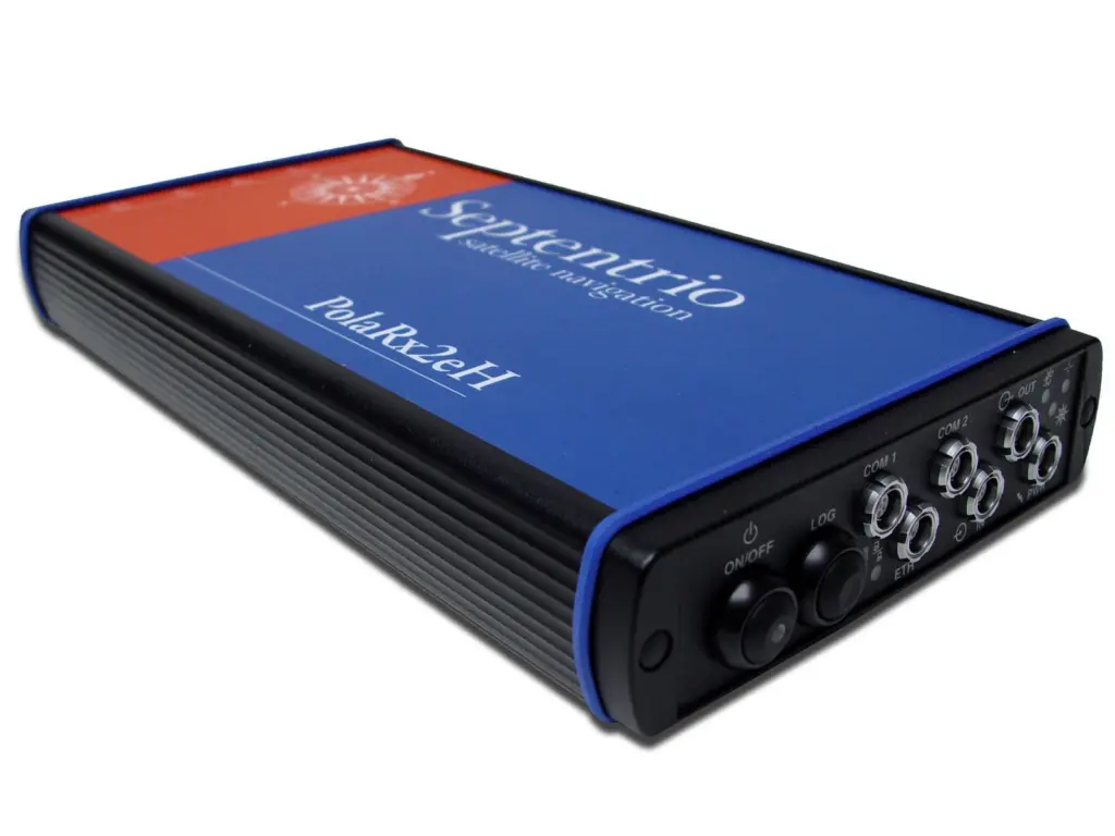
Finding a solution to this and other problems associated with container location has been the premise behind the development of Septentrio Satellite Navigation’s EGNOS enabled PolaRx2 receiver.
According to a Septentrio White Paper published in connection with a project undertaken with PSA a few years back, there are some issues with the coverage of a typical GPS. While a GPS receiver can be used to log the pick-up and drop location of each container to counter any ambiguity, the GPS receiver needs to deliver a solution which is accurate to 1.7m since this corresponds to half the width of a standard container.
However, for a typical GPS receiver signals can be blocked by the size of the ships and port handling equipment at the terminal, providing an intermittent service when the requirement is for a system capable of 24/7 operation. Metallic surfaces can also reflect the signal, so most new systems on the market incorporate ‘multipath mitigation’ techniques.
At the heart of Septentrio’s GPS is its PolaRx2 receiver. This, according to the Belgian company, provides accuracies from 1.2m-2m down to 2cm-5cm. Special firmware is used to limit the influence of reflections and to re-acquire the GPS signals very fast after signal interruptions.
To deliver 99.9% accuracy, Septentrio has also used information from the European Geostationary Overlay System (EGNOS), a network of ground stations and geostationary satellites that continuously monitors and corrects GPS data thus enhancing a position and detection system.
Unlike other Differential GPS techniques, a separate reference receiver isn’t required and there is no need for a radio infrastructure to send corrections from the reference receiver to the receivers on the straddle carriers.
For the PSA project, Septentrio worked together with the container terminal to create a link between the PolaRx2 receiver and the central yard-management software so that a position message was emitted every time a container was picked-up or dropped-off. So if the straddle carrier driver picks up a wrong container, or drops one off at the wrong location, the management system will automatically send a warning to the dispatcher.
Since it implemented the system to all its straddle carriers at the Antwerp container terminal, PSA has noticed a discernible reduction in the number of containers going astray and, subsequently, increased throughput productivity.
“Before we started using GPS to track our containers, the position of a significant number of containers on the yard did not match the expected position,” says PSA’s Noel Thielman. “With the new system installed this number had been reduced by more than 90%. After investigation these remaining errors were traced back to situations where the straddle carrier driver did not follow the instructions correctly. However, thanks to the logging of the positions in our system, we could find them back easily.”
Related Articles
 CONTAINER & CARGO HANDLING
 CONTAINER & CARGO HANDLING
 BULK HANDLING