

Using tidal waters to create coastal habitats
Managed realignments can be used as sites for beneficial sediment use to create coastal environments. Colin Scott and Susanne Armstrong of ABP Marine Environmental Research Limited (ABPmer) review some examples.
In coastal and estuarine locations, the process of deliberately allowing tidal waters to flood across formerly ‘dry’ land in a controlled way is being increasingly pursued to create new coastal habitats and manage flood risks. While the precise way in which this is undertaken at any given location needs to be carefully considered to take account of site-specific and community-specific factors, in very broad terms two methods that can be applied to achieve this:
• Managed Realignment
• Regulated Tidal Exchange
Managed Realignment (MR) essentially involves the controlled breaching of existing seawalls, to allow tidal water to move in and out in an unconstrained manner; while Regulated Tide Exchange (RTE) seeks to control the volume of exchange using sluice gates, weirs or pipes rather than full breaching of the sea wall. RTE is therefore seen as the best approach in areas where there is a limit to the amount of water that the adjacent tidal estuary can cope with or where breaching is inappropriate for other reasons. Since they were first implemented in Europe in the late 1980s, a total of some 91 MR and RTE schemes have been undertaken across North-West Europe, employing a variety of techniques and creating a range of habitats. Of these, there have been 30 MR and 11 RTE schemes in the UK alone.
Increasing experience
The first MR in the UK occurred at Northey Island (Blackwater Estuary) in 1989, but it was only in the mid-90s that the next schemes were implemented (for example at Orplands and Tollesbury). The lessons learned from these early projects – and those that succeeded them – have provided coastal managers with increasing confidence about the effectiveness of such measures. These case-examples have also been useful for communicating the rationale and benefits of such schemes to the general public and have allowed steady improvements to be made in the quality and quantity of these projects. The pattern seen across North-West Europe as a whole is that they have evolved from often ad-hoc initiatives, to a new generation of sophisticated projects which are meticulously planned, consulted on and monitored. They have also increased in size so that while less than 500ha had been created in the UK by 2005, in 2006 three large schemes at Alkborough, Wallasea and Chowder Ness were undertaken that increased this to around 1000ha in a single year and by early 2009 a total of 1250ha has been created. MRs are also increasingly being seen as a mechanism for delivering multiple functions beyond their core habitat creation and flood project objectives by, for instance, providing recreational, fisheries and nutrient/carbon processing benefits. Further details on these schemes can be found in ABPmer’s online database which collates case-specific information on MR and RTE projects across Northern European (www.abpmer.net/omreg).
Use of sediments
Just one of the past lessons that can be learned relates to the beneficial use of unwanted sediments from ports and construction sites. These sediments can be used to raise ground elevations and to landscape the area that is going to be flooded. In small sites and areas with rising ground there can be little need for landscaping or even for new sea wall construction (e.g. Abbotts Hall on the Blackwater). However, in most instances, the newly flooded land is low-lying coastal flood plain (often lower than the coastal habitats that surround it due to land settlement) and therefore a new seawall will be needed to protect the hinterland and imported sediments can be required to raise land levels and thereby to: enhance the defences; create the correct mix of habitats and ensure that, after breaching, the volumes of tidal water exchange are reduced. Effectively using imported materials for shaping the land therefore represents just one of the factors that will be pivotal for the successful delivery of future projects especially if these are to be achieved on a large scale.
Wallasea Island
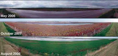
The value of imported sediment has been demonstrated most clearly on Wallasea Island (Essex) where, for a Defra-led MR project on the north bank of the island, land raising was needed to create the correct topography for salt marsh habitat creation. This was achieved by importing 700,000 tonnes of pollutant-free dredged material from the Port of Felixstowe which might otherwise have been dumped at sea. This was bunded into a 23ha area at the top of the shore and land levels were elevated by around 2m. When the sea walls were breached in the summer of 2006 it was just barren sediment but in just two years it was rapidly colonised by salt marsh plants such that it now has a full ‘carpet’ of vegetation. Although it will be many years before it becomes a mature marsh, this demonstrates that functional and visually attractive marsh habitat can be created rapidly using these sediments and with limited intervention. Wallasea Island also represents a potential location for an even more innovative – and much larger-scale – use of imported sediments as part of a MR scheme that will cover the rest of the site. This project has been proposed by the Royal Society for the Protection of Birds (RSPB) and there is no doubt about the urgent need for intervention of this sort because the island is at very real risk of an unmanaged flood event within the next few years. As the island is so low-lying, the vast volumes of water that it would exchange with the Roach Estuary after such an event would be sufficient to cause damaging levels of erosion that would greatly increase flood risk to other areas. It would also fundamentally change the way the whole estuary functions and constrain how it can respond to sea level rise in the future.
Raising land levels
Initially, an RTE approach was seen as the way to manage the tidal exchange volumes in such a large and low-lying site. However, in early 2007, the project team – in consultation with Governmental agencies charged with licensing coastal developments and marine sediment disposals – recognised that sufficient inert fill material (several million cubic metres) could be obtained from the London Cross rail project to substantially raise land levels across much of Wallasea Island. This restoration of the sunken land levels would then allow a more natural looking and more sustainable MR project, because it would reduce the volumes of water exchange that would occur from an open breach of the sea wall. What emerged was a partnership between Cross rail and the RSPB, alongside their technical advisors (ABPmer and Faber Maunsell), and together this team has designed the scheme, consulted widely and undertaken the necessary Environmental Impact Assessment work. The final proposed scheme design has been developed to not only raise the land levels as required but also to manage the direction of the flows, avoid affecting shell fishing areas; ensure that the site has plenty of room to accommodate future sea level rise and provide locations for recreational activity. These two projects (one complete and one proposed) represent just two good examples of beneficial sediment use and it will be very important that the practical lessons learned from these feed back into the accumulating knowledge-base about MR and RTE projects in order to continue the process of improving the implementation of these projects in UK coastal waters.
www.abpmer.co.uk
Related Articles
 ALTERNATIVE FUELS GREENPORT