

LOOKING INTO THE ‘DARK’
Ron Crean of London-based Windward, outlines what ports and terminals need to be wary of to be safe from sanctions.
Since 2017, a growing focus on sanctions has created a dramatic increase in the related risks faced by the maritime ecosystem. Maritime suppliers, banks, commodity traders, insurers and shipping companies are all more exposed to the risk of financial penalties and reputational damage.
Those who provide services that enable trade in sanctioned goods, such as port operators, are also exposed through the parties with whom they deal and the goods they are transporting. Ignorance is no longer a viable defence; operators need to take steps to avoid handling sanctioned goods.
It has been a consistent theme for regulators to increase the expectations on all parties involved in the maritime supply chain. All marine businesses must now know the counterparties they are dealing with and the history of vessels with whom they work.
Ports must be able to check the background of all vessels and show bodies such as OFAC that they have the technology to screen ships for suspected sanctions evasion. This puts the burden of implementing various sanctions screening programs firmly on the back of the maritime business community, obliging organizations to analyse several million pieces of data every day.
And of course, this stance by sanctioning bodies requires due diligence into past port calls and suspicious activities in high-risk areas. But the scale of the problem now requires resources and a reflex response that many ports simply don’t have at their disposal.
Meanwhile, screening itself is not always straightforward. Analysis of the global fleet for sanctions risk over the past six months reveals some interesting insights:
There are twice as many vessels behaving suspiciously than those that are officially considered high-risk and appear on various sanctions lists. 5 Iran (and the broader Gulf region) are the top locations when it comes to vessels with suspicious activities.
‘Dark’ activity, i.e. ships concealing their location and operations by turning off their AIS transmissions, is the most popular of the deceptive shipping practices described in recent U.S. (OFAC) and UN advisories.
So how do port and terminal operators stay safe from sanctions? What should they be looking for?
Seeing in the ‘dark’
Key for anyone interested in whether vessels are behaving suspiciously is the use of tracking data from vessels’ Automatic Identification System (AIS). This means organizations can screen the movement of ships they do business with for signs of illicit activity, such as smuggling, trafficking, or sanctions evasion.
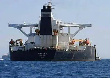
Gaps in vessels’ AIS transmissions for more than eight hours are defined by OFAC as a red flag for sanctions evasion. Analysing tracking data shows ‘dark ‘activity – when AIS is turned off – in the Gulf increased 41% in 2019 compared with 2018. In July last year, the Grace 1 became the poster child for this sort of evasion, after being detained in Gibraltar carrying Iranian oil. What’s perhaps even more troubling is that the Grace 1 is not an isolated case of oil sanctions evasion. The practice of going ‘dark’ is growing in scope.
But going ‘dark’ is not in and of itself a sign of guilt; not every transmission loss should be treated as a red flag. However, there are three other simple signals to look for when screening a ship’s past periods of non-transmission:
Quality of AIS coverage
Time unaccounted for
Feasibility of ‘dark’ trade
Quality of AIS coverage
The very first step is to assess the quality of AIS coverage at a particular point in time and space. AIS signals are often lost due to insufficient receiving stations or signal collision. But if no other vessels in the vicinity had an issue with their transmissions, it seems unlikely it’s a problem specific to one vessel. Since AIS coverage is usually best near ports and shores, lost events that are less than 30 nautical miles from shore are more likely to be ‘dark’.
Time unaccounted for
Next, measure how much time cannot be accounted for. This is a bit more complicated, but the basic idea is to establish the distance between the point at which the AIS signal was lost and the point at which it was found. You then use the vessel’s known sailing speed (either regular sailing speed, speed before/after lost, or average of the two) to calculate how long it should have taken the ship to travel between the two points. If the two fail to match, then the question you need to ask is simple: what was it up to during that time?
This question will be answered in Port Strategy’s May 2020 follow-up.
Related Articles
 CONTAINER & CARGO HANDLING
 TERMINAL OPERATIONS
 CONTAINER & CARGO HANDLING