


Modelling a deeper channel
Rafael Cañizares of Moffatt & Nichol, explains how a channel modelling project undertaken by the company in Colombia enabled significant savings to be made.
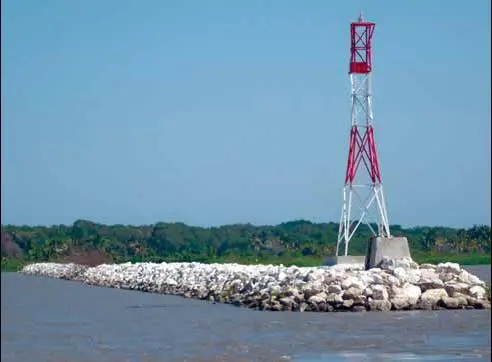
Barranquilla is the largest city on the Caribbean Coast of Colombia; and the City’s port, on the Magdalena River, is an important multi-purpose port for the country. The ship access channel from the mouth of the River to the cargo terminals on has historically presented navigation restrictions for ocean going vessels. Recent studies indicate that the depth of the channel is the main factor limiting plans to increase the Port of Barranquilla’s competitiveness. The port facilities in Barranquilla require a 12.19 m (40 feet) deep access channel in order to accommodate 35,000 TPM (Handymax type vessels) ships without restriction. The Instituto Nacional de Vias (Invias), a division within Colombia’s Ministry of Transportation, has undertaken a number of studies over the years to develop a plan that can ensure the required channel depth for cargo ships to access to the main terminals of the Port of Barranquilla. These studies identified two critical shoaling locations – near the river mouth and at Isla 1972 – which have required a significant amount of dredging in the past. As a result, a branch of the Magdalena River east of Isla 1972 was closed off in 1994, forcing all the river flow along the main channel. To permanently improve the navigation conditions, a feasibility study was conducted in 1999 and updated in 2002 which proposed the construction of a number of groin-type structures (called Espolones in Spanish) to create a contraction of the river’s cross section. The contractions would increase flow velocity and thereby scour the river bottom to the depth required for safe navigation, without the need for regular maintenance dredging.
Public contest
In early 2005, Invias opened a public contest for the Deepening Works of the Access Channel to the Port of Barranquilla, the goal of which is to create a stable navigation channel with a minimum depth of 12.19 m (40 feet) in the Bocas de Ceniza and Siape area (the first 12 km from the mouth), 11.43 m (37.5 feet) to the Port of Barranquilla, and 10.97 m (36 feet) at the port basin. Although these are the design depths for the contract, upstream of the structures the natural channel is more than 12.19 m (40 feet) deep and has been in a very stable situation at least in the last decade, therefore it is expected that the navigation channel could have a depth of 12.19 m (40 feet) along its 22 kilometers. The contract was awarded to the Consorcio Canal del Rio (CCR) a Joint Venture of three Colombian Companies: Conalvias S.A., Inacol Ltda. and Proycol Ltda. Invias’ scope of work for the project included a hydrodynamic and morphological numerical model to test the possible alternatives; a wave model to calculate design wave conditions at the river mouth; and a navigation study to test the final access channel configuration with the design vessel, as well as final design and specifications for the proposed structures. Moffatt & Nichol was retained to carry out all these tasks with review and oversight from Invias by the Consorcio Restrepo y Uribe – Ingeco, led by Dr. Pedro Gutierrez Visbal and the Universidad del Norte, led by Prof. Manuel Alvarado.
3D model
Moffatt & Nichol developed a threedimensional morphological model of the last 22 kilometers of the Magdalena River using the Delft3D numerical modelling system. The model was calibrated to reproduce observed water levels and velocities in the river. In addition, historic bathymetric data were provided by Universidad del Norte and used to calibrate and validate the numerical model to reproduce observed multi-annual morphological changes, so that the model could be used with confidence to predict morphological changes associated with specific alternatives. The initial alternative identified by Invias consisted of 4 groin-type structures. Initial simulation of this alternative suggested the possible need for modification of the proposed structures as well as the construction of additional structures to achieve the deepening goal and also to avoid possible Negative impacts on existing river structures. The morphological simulations carried out to analyze the river behaviour for each alternative started with all the structures simultaneously completed. This conservative assumption was considered only for modelling purposes due to the uncertainties associated to the construction process. In fact, the structures were not constructed in the exact order originally planned due to some unexpected challenges and technical difficulties encountered during the construction process. Morphological simulations predicted a temporal discontinuity of the channel at the curve downstream of Siape that could last several years, caused by the accumulation of all the eroded material by the five upstream structures. Although two additional small structures were included at the curve to provide continuity in the navigation channel, its final design and construction depended on the channel conditions after the construction of the structures in Siape. Another possible solution in this area, if the real discontinuity was not as significant as expected, consisted of dredging the area until the river bed has stabilized. All of the structures include a scour protection system used at the end of each groin which includes a falling apron – a toe protection that can adjust to scour and follow any bed erosion downwards. In theory, the apron will initially contain a volume of rock sufficient to cover the maximum length of the eroded slope and to retain the bed material. Nearly 200,000m3 of sand was dredged from the two structures at the mouth of the river to place the falling apron at the design depth. Dredging was performed by the Port of Barranquilla’s dredge “La Arenosa” at the deeper areas and Dragados Hydraulicos “la Catleya” for shallower areas.
Construction programme
Construction began on Moffatt & Nichol’s final designs in May 2006 with Espolón 1, which was completed within four months. Espolones 0, 2 and 3 were completed in November 2006, February 2007, and June 2007, respectively. Because of the gradual construction of the structures and the conditions in the river during construction, the temporal discontinuity of the channel at the curve downstream of Siape did not occur, remaining the channel deeper than the design depth. Moffatt & Nichol then carried out an additional study to assess the need for Espolón 4 and the conclusion of the study was that the navigation channel was already stable with the design depth and that the additional structure was not required. Construction is ongoing at Bocas de Ceniza, where strong river flows and offshore waves entering the mouth of the river presented difficulties. Construction was completed at the end of 2008. The two structures projected in this area, a groin type structure (Espolón 6) and a T-groin type (Dique Guía / Dique de Cierre) include a protection layer in the design to withstand a 50-year return period design wave, calculated from Moffatt & Nichol’s wave model. In addition, the rock for the protection layer was obtained from a different quarry because using a higher density rock allowed for the design of smaller structures, resulting in a cost reduction.
Design depth reached
The ongoing monitoring carried out by Universidad del Norte shows that as today the navigation channel has reached the design depth and width from approximately kilometer 0 at the mouth of the river all the way to the SPRB terminal which is close to the Puente Pumarejo which is the upriver limit for ocean going vessels. Recent surveys show a depth limitation in the navigation channel just offshore of kilometer 0, in the form of a sediment bar across the channel. It is expected that conditions in this area should gradually improve after construction is completed, reaching the required width and depth in this area within a year or two. This process could be accelerated by dredging in the order of 100,000m3 (based on October 2008 survey) in this area providing a continuous navigation channel to the Regional Port Society of Barranquilla of 12.19 m (40 feet). www.moffattnichol.com
Related Articles
 ALTERNATIVE FUELS GREENPORT
 OPERATIONS
 ALTERNATIVE FUELS GREENPORT